The Hells Canyon National Recreation Area, in the remote northeast corner of Oregon, is part of the Wallowa-Whitman National Forest and is between the borders of  northeastern Oregon and western Idaho. The area encompasses 652,488 scenic acres and over 900 miles of trails. In its deepest part, Hells Canyon drops 8,000 feet to the Snake River, making it the deepest river gorge in North America. After some research, I chose the destination of Bear Mountain, which offered a rather short hike and some of the greatest and most expansive views of Hells Canyon.
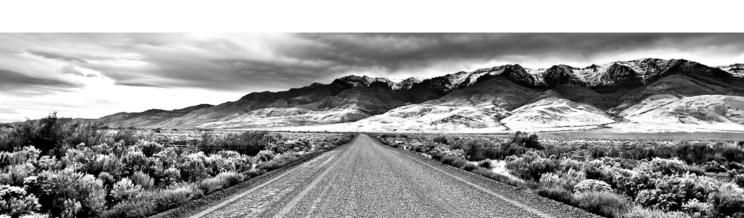
My trip began with a 360 mile drive from Portland to the extremely small town of Imnaha in Oregon.From Imnaha, I drove 17 miles east on Hat Point Road (Forest Road 4240) to the Summit Ridge Trailhead.As it was late, I decided to spend the night at the trailhead which offered a great view for photography and a nice place to camp and.Being early October, the weather was unpredictable and the forecast called for thunderstorms and lows in the 30s.That evening a wind storm barreled through the canyon which sounded like a freight train and rocked me back and forth in my tent all night long.In the morning, the sun broke, and with scattered showers I hiked approximately 6 miles to the summit ridge behind Bear Mountain.The hike begins on the Summit Ridge Trail #1774 with a pointer towards Freezeout Saddle. The hiking trail soon dropped 1,000 feet over a span of two miles.A mile into the hike you can get a clear view of Bear Mountain.At one point while facing Bear Mountain there is a clear view on your left of the Seven Devils Mountains on the Idaho side of the area.Eventually the trail levels out and you are at the base of Bear Mountain.At this point there is a sign post with markers to a 9 mile hike down to the Snake River and another marker to the Freezeout Trailhead, which is 2 miles.However, there is no sign marking that you are in front of Bear Mountain or that continuing straight takes you around the mountain.Just continue straight along the Summit Ridge Trail #1774.This trail will climb and wrap around the side of the mountain.
From the base of Bear Mountain I continued on for 4 miles and wrapped around the mountain and then was hiking along a ridge. When the ridge opened up, I had a spectacular view of Hells Canyon below and  decided to scramble a few yards off trail and set up my tent. Immediately after taking my gear out of my bag, a fierce sleet storm dumped sleet and rain for 30 minutes and soaked all of my gear while I was struggling to put up my tent in the wind, rain, and cold. Fortunately, I had an extra pair of dry and warm clothes and I was able to warm up a bit and started a fire. I enjoyed the views and a hearty portion of Kung Pao Chicken and sat by the warm fire until 8:30 pm when lightning and thunder began to strike right above me without warning. Knowing that I was not the highest point on the ridge and not near any large trees, I felt semi-safe however, when it began to pour buckets, it was an early night in my tent as there was no way that anyone could sit out in that fierce of a rain storm. Later that night, after my tent was smacked around in the wind and rain, it began to snow. When I woke early that morning, half an inch of snow blanketed the area and the thermometer on my pack said it was 28 degrees. After packing up my wet and frozen gear, I hiked the 6 miles back to the trailhead and warmed up in the car.
I would say that being late in the season (as the place does shut down early November), there were very few others hiking and backpacking in the canyon. Hunting season recently opened and there were a few hunters in  the area however. Hells Canyon must be one of the most remote places in the Pacific Northwest you can dare to venture in. The canyon is spectacular and lives up to its grandeur as being the deepest river gorge in North America. I only saw a small glimpse of the area while on my trip, but I could see that the canyon went on for miles. This is certainly a place I plan to explore further, especially the famed Seven Devils. I would recommend Hells Canyon as a top hiking and photography destination in Oregon and since the area is so vast, you truly can pick any adventure you like and make it your own. With its mountain vistas and steep canyon drops, Hells Canyon is prime for landscape photographers looking for dramatic skies and unrestrained views. I encourage you to explore Oregon and make your own adventure.
To Get There:
From Joseph, Oregon drive 30 miles northeast on Oregon 350 to the small town of Imnaha, Oregon. From Imnaha take Hat Point Road (Forest Road 4240) which is a steep gravel road that is well-maintained for 17 miles to the Summit Ridge trailhead. There is a sign noting the Summit Ridge trailhead and mile post markers noting the miles traveled.
Certainly four-wheel drive vehicles are recommended, however, a passenger car could make it to the trailhead, although, 17 miles on a gravel road would take its toll on your passenger car. There is no water at the trailhead, and no water along the hike to Bear Mountain. There is no gasoline in Imnaha and the nearest gas station is in Joseph which is 30 miles away so be sure to gas up. The Imnaha Tavern & Store has pretty decent food and some basic supplies. The burger was great, but I passed on the frog legs and chicken gizzards.

Oregon Photo Guide™ features the landscape photography of Michael Skourtes, Bend Oregon photographer and avid outdoorsman. I venture throughout the state searching for the top destinations for Oregon hiking, backpacking, camping, and photography. I share my experiences and photography of Oregon on my guide. I encourage you to explore Oregon and make your own outdoor adventure.