
Lake Owyhee State Park is an oasis in the middle of the spectacular desert canyons located 28 miles south of Ontario in Malheur County, Oregon. The state park is home to the Owyhee Reservoir, a 53-mile lake formed by the damming of the Owyhee River.  This man-made body of water known as Lake Owyhee, which is the longest in Oregon, offers prime high desert scenery with the Owyhee Mountains to the east and surrounded by long desert buttes and hills amidst craggy and towering peaks known broadly as the Owyhee Uplands. Outdoor recreational activities include fishing, boating, camping, hiking, hunting, wildlife viewing, rock hounding, and landscape photography. The lake is noted for excellent fishing for largemouth and smallmouth bass, crappie, walleye, brown bullhead, yellow perch, catfish, and trout. The surrounded area is home to abundant wildlife including bighorn sheep, pronghorn antelope, golden eagles, coyotes, mule deer, mountain lions, and wild horses. Truly a wild and sparsely populated area, Lake Owyhee State Park is the ideal base camp for hiking and exploring Oregon’s badlands.
The key feature of the lake, creating what would be an otherwise barren landscape, is the Owyhee Dam on the Owyhee River. The dam rises 417 feet and is 835 feet long. Interestingly, at the time of its construction (1928-1932), it was the world’s highest dam.  Owyhee Dam was a testing ground for theories being developed to assist with the design and construction of Hoover Dam, whose size is 300 feet higher than Owyhee, and was vital in developing these new construction methods. The result of damming the Owyhee River results today in 53 miles of water filling the narrow and deep canyon walls with highly colorful geological formations formed by eons of volcanic eruptions and weathering from the passage of time.
In 1984, the U.S. Congress designated 120 miles of the river as Owyhee Wild and Scenic River under the Wild and Scenic Rivers Act of 1968 to preserve the river in its free-flowing and natural condition. Part of this designation includes the section of the river downstream from the Owyhee Dam.  This is where the river flows through a remote section of deeply incised canyons surrounded by high canyon rims and are habitat for the wildlife in area. The 346 mile long Owyhee River, is a tributary of the Snake River located in portions of three states: northern Nevada, southwestern Idaho, and southeastern Oregon. The Owyhee River flows through the Owyhee Plateau, and is responsible for cutting deep canyons, often with dramatically sheer vertical walls that in some places are over 1,000 feet deep. The name of the river is from the older spelling of “Hawaii”. It was named for three Hawaiian trappers, who were hired by the North West Company, and were sent to explore the uncharted river. They failed to return to their rendezvous point near the Boise River and were never seen again.
There are two campgrounds at the park with seasonal camping from April 15th through October 31st. The main McCormack Campground has 29 RV electrical sites with water, nine tent sites with water nearby, two tepees, hot showers, toilets, with paved parking, and picnic tables.  The Indian Creek Campground has 27 RV electrical sites with water, and five primitive tent sites. Both campgrounds have a boat ramp for access to the lake. The Gordon Gulch day-use area has a boat ramp and a large, shaded picnic area.
A destination to highlight with a modest drive from Lake Owyhee State Park area, is a remote haven for rockhounds searching for thundereggs and gemstones, called Succor Creek State Natural Area. This Owyhee Canyonlands landscape makes for a great base camp for day trips into the Painted Canyon, Honeycombs, and Leslie Gulch. Limited souvenir collecting by rockhounds is permitted in the area. There is a rough 15 mile dirt road which leads from Oregon 201 to Succor Creek. At the Succor Creek Campground, there is walk-in primitive tent camping and day-use areas on the east side of the creek. There are primitive tent sites on the west side of the creek, and no potable water is available in the area. Although, water can be found in the creek as long as it is filtered or treated. The name Succor Creek refers to early travelers in the Snake River Basin who, having been saved by the creek’s vital water, applied the name as a corruption of the Spanish word “socorro”, meaning to help or aid.
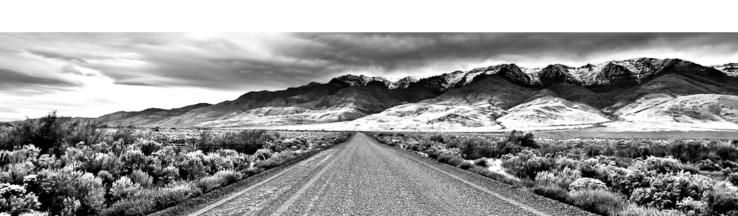
While there are the designated campgrounds at Lake Owyhee State Park, some of the best camping is not within the state park itself, but rather in the open and rugged areas along the astounding Owyhee River. The highlight of the area is the 22-mile drive to the state park on Owyhee Lake Drive. Along this picturesque drive, the scenery is breathtaking and some of the finest in Oregon. There are several small offshoots from the main road where you can find the perfect rustic spot to make your own camp, fish along the river, or start off on a hike to a gulch seen in the distance.
 Owyhee Lake Drive takes you deep into desert country and winds through countless turns through the narrow Owyhee Canyon and along the meandering Owyhee River. The view along this journey captures everything an outdoorsman and landscape photographer desires. From orange mountain cliffs with burnt red striations of volcanic ash, to vari-colored tuffs with bands of yellows and shades of lavender. The drive features desert plateaus with sage brush with silvery tips and dry grasses forming fields of brown. With gray sand and stream deposits along the banks of the flowing Owyhee River, and the oasis of green surrounding the water, the area represents many spectrums of sensational color.
 From spectacular landscapes to an abundance of wildlife and hiking opportunities to explore, Lake Owyhee State Park and the highly recommended Owyhee Canyon is a top destination in Oregon to explore and photograph Oregon’s wild and majestic badlands.
To Get There:
Lake Owyhee State Park is off Highway 201, 33 miles SW of Nyssa, Oregon. From Highway 201, turn west at Owyhee Junction onto Owyhee Avenue for 5 miles, then turn south (left) onto Owyhee Dam Cutoff Rd for 22 miles to the park.

Oregon Photo Guide™ features the landscape photography of Michael Skourtes, Bend Oregon photographer and avid outdoorsman. I venture throughout the state searching for the top destinations for Oregon hiking, backpacking, camping, and photography. I share my experiences and photography of Oregon on my guide. I encourage you to explore Oregon and make your own outdoor adventure.