Ice Lake, in the Eagle Cap Wilderness of Oregon, is a pristine and magnificently scenic alpine lake nestled at the bottom of the Matterhorn and Sacajawea Peak of the Wallowa Mountains of Oregon. Known as the “Oregon Alps”, the Wallowa Mountains are a scenery-packed wonderland of splendid beauty.  Home to 17 mountains that eclipse 9,000 feet and derive from the Nez Perce word for “land of running waters,” the Wallowas of northeastern Oregon offers the state’s best backpacking experience. The 15.5 mile out-and-back hike to Ice Lake is the premier hike to witness the magnificence of this unspoiled landscape and experience a portion of Oregon that is unrivaled in adventure. Not only is the destination beautiful, but so is the journey. The hike takes you through lush wildflower meadows, a forest canopy of dense pine and fir trees, and plunging waterfalls. Since the trek is so remarkable, it is the most popular hike in the Eagle Cap Wilderness; which is Oregon’s largest and most spectacular wilderness.
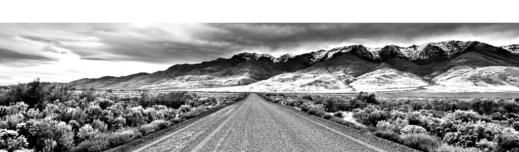
The Eagle Cap Wilderness lies in the heart of the Wallowa Mountains in the Wallowa-Whitman National Forest and totals an amazing 350,461 acres of wilderness. The Eagle Cap Wilderness is known for its high alpine lakes and granite peaks and ridges.  The sixth highest peak in Oregon and the highest in the Eagle Cap Wilderness is Sacajawea Peak at 9,838 feet. Hikers can choose from approximately 534 miles of hiking trails in the Eagle Cap. Trailheads are located on all sides of the wilderness, with access from the counties of Wallowa, Union, and Baker. Eagle Cap Wilderness is named after a peak in the Wallowa Mountains, which were once called the Eagle Mountains. The wilderness gets its name from Eagle Cap, which at 9,572 feet, was incorrectly thought to be the highest peak in the range. Four designated Wild and Scenic Rivers originate in Eagle Cap Wilderness: the Lostine, Eagle Creek, Minam, and Imnaha. Eagle Cap Wilderness is home to a variety of wildlife, including black bears, cougars, Rocky Mountain bighorn sheep, and mountain goats. In the summer, white-tailed deer, mule deer, and Rocky Mountain elk roam the wilderness. Due to heavy winter snowfall, the area typically does not open until mid-summer and fall.
Ice Lake, at an elevation of 7,849 feet, is a deep, still-water alpine lake 49 acres in size and 193 feet deep. The lake is a rich blue color and is entirely accessible by trail with primitive campsites around the lake.  Ice Lake and the surrounding alpine meadow is a tranquil timberline environment that is surrounded by wildflowers with mountain views in every direction. While the lake gets many visitors, the landscape remains unchanged, primarily given that a 15 mile backpacking trip tends to weed out types of individuals who do not respect such a pristine environment. Since summer weekends can be crowded, planning a trip mid-week is your best bet for a greater chance of solitude. The hike opens after the snow melt which is usually mid-July and ends at first snowfall which is usually sometime in October. The trail is shared by both hikers and horses.
The hike beginning at the Wallowa Lake Trailhead is 7.5 miles and gains an elevation of 3,400 feet before reaching Ice Lake.  The hike is considered difficult, although the elevation gain is spread out over the length of the hike, with a final push through a series of steep switchbacks. There are a few spots where you would certainly not want to slip, but otherwise you just need stamina. To begin the hike, take the West Fork Wallowa River Trail #1820 and soon cross a bridge over the West Fork of the Wallow River. Continue to head up a dusty tread, well-trodden by mule and horse trains. It is a slow uphill climb, with many switchbacks along the way. The first three miles follow the roaring West Fork Wallowa River before a cutoff for Ice Lake Trail takes you across a log bridge and uphill. Follow the Ice Lake #1808 trail; along the way are meadows sprinkled with wildflowers and plunging waterfalls. There are many areas to take a break and enjoy the scenery. One of the finer spots is at mile 5.4, where Lower Adam Creek Falls thunders into the canyon and Upper Adam Creek Falls can be seen in the distance above. The trail continues to climb through high country meadows until finally reaching an alpine bench with Ice Lake soon in view.
Most campsites are to the left of Ice Lake which you approach after crossing Adam Creek. The most popular campsites are on a small peninsula that juts into the lake from the east shoreline.  This small peninsula is the prime camping area. There is one spot on the peninsula in particular that is considered the best, so if you arrive at the lake and see that it is free, be sure to claim it. The south shore is mainly a swampy marsh, although because a trail runs around the shore, it is not difficult to find a nice place to camp as long as you are 100 feet away from the water. The lake is fed by snowmelt running down from the steep sides of the granite mountain slopes and is fresh and ice-cool to drink. Fishing is popular along the banks of Ice Lake for brook trout (mostly 7-8 inches in length) with no limit on the size and number of brook trout taken. Firewood can be scarce at times and there are no fires allowed near the lake. Mountain goats and bighorn sheep may sometimes be seen from camp, usually on the ridges to the north of the lake.
To the north of Ice Lake is the long ridge of the Hurwal Divide. Looming to the west is the Matterhorn with its characteristic dark limestone capped by white marble.  Sacajawea Peak is just northwest of Hurwal Divide, 1 mile north of Matterhorn, and 1.4 miles northwest of Ice Lake. Sacajawea Peak is characteristized by its large red-colored scree mound from the east. Sacajawea Peak is connected by high ridges to the Matterhorn. Both are connected to the Hurwal Divide by a high ridge extending east and north from Sacajawea and Matterhorn. A high pass connects Hurwal Divide to Chief Joseph Mountain to the north. Ice Lake makes for a basecamp for those who wish to make the climb. Sacajawea Peak is reached from Ice Lake across a saddle in the Hurwal Divide and up lots of red scree on the southeast side. There are a handful of gendarmes that must be navigated around in order to get to Sacajawea after reaching the unnamed peak at 9,775 feet in elevation. Scrambling is required in order to climb to Sacajawea Peak from the Matterhorn and is a more dangerous route.
Ice Lake in the Eagle Cap Wilderness is the premier alpine lake in Oregon. While many are content with admiring the beauty of the Wallowas from a distance there is no finer experience than hiking into the core of the wilderness and camping among nature in a pristine environment. 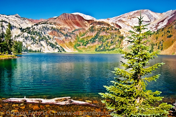 The scenery is remarkable, with photo opportunities in every direction. One view in particular is the stillness of Ice Lake; it creates a perfect mirror reflection of the route up the back side to the Matterhorn, especially at sunrise when the orange and red hues are present. Plan on spending two nights at the lake, so that you can experience one full day from sunrise to sunset in this alpine wonderland. From relaxing by the lake, to fishing, or making a climb up to Sacajawea Peak, Ice Lake offers a reward to all who make the trek. In my opinion, Ice Lake is the top destination in Oregon for hiking and photography.
To Get There:
From Portland, drive on Interstate 84 to La Grande exit 261. Take Highway 82 and follow the Wallowa Lake signs through Enterprise and Joseph. While on Highway 82, you reach Wallowa Lake and stay on this road until you reach the end of the road with the Wallowa Lake Trailhead on your left for a total of 335 miles. There is a picnic spot and public restrooms in the parking area. A Northwest Forest Pass is required to park. At the trailhead there is a self-registration box for your camping trip, which is free.

Oregon Photo Guide™ features the landscape photography of Michael Skourtes, Bend Oregon photographer and avid outdoorsman. I venture throughout the state searching for the top destinations for Oregon hiking, backpacking, camping, and photography. I share my experiences and photography of Oregon on my guide. I encourage you to explore Oregon and make your own outdoor adventure.