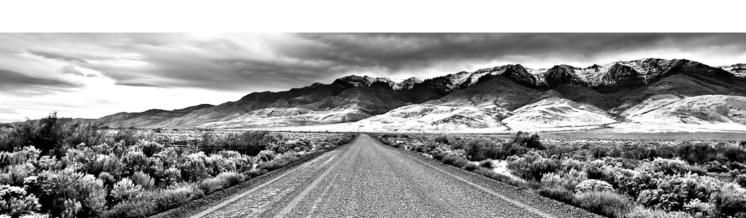
The North Fork John Day Wilderness along the North Fork John Day River Trail deep in Oregon’s Blue Mountain gold rush country is prime backpacking country. The 25 mile-long trail follows the John Day River downstream through a rimrock canyon featuring forests of Douglas Fir and lodgepole pines, rocky outcrops, smooth meadows, and  decaying log cabins of Oregon’s gold rush pioneers. The North Fork John Day drainage was a bustling gold and silver mining area in the middle to late 1800s. Old mines, log cabins, water-worn rock, dredged ditches, and other traces are still visible of people who mined an estimated $10 million in gold and silver in the early days of Oregon.
The North Fork John Day Wilderness was established by the Oregon Wilderness Act of 1984 and is comprised of 121,800 acres. A 39 mile segment of the North Fork John Day River has been designated as a Wild and Scenic River. The river is “Wild” meaning it is undammed along its entire length and is the third longest free-flowing river in the lower 48 of the United States. The area’s fish population includes large numbers of Chinook salmon and steelhead, with runs that peak in August. This area is well known for big-game animals, which currently include a herd of Rocky Mountain elk estimated to number beyond 50,000 and a herd of mule deer that reportedly exceeds 150,000. The wilderness also has its fair share of black bears and mountain lions and in the fall, the North Fork John Day River Trail is a prime trail for big-game hunters.
Hikers can access roughly 133 miles of trails, three of which, Elkhorn Crest, Winom Creek, and North Fork John Day, are National Recreation Trails. Interested in Oregon hiking, and a scenic tour of the wilderness along the John Day River, I planned an overnight photography and backpacking trip with my friend Spencer. We planned to start at the North Fork John Day Campground which is located southeast of Ukiah, Oregon and 9 miles north of the small town of Granite, Oregon. The campground is the trailhead location for the North Fork John Day River Trail #3022 which runs 25 miles down the river. We planned to hike roughly 6 miles downstream to find a nice place to camp along the river and return back along the trail to the trailhead the following morning.
We set off from the trailhead which is at an elevation of 5200 feet, and after just 200 yards through a wet meadow we turned right to cross a wooden footbridge across Trail Creek. From here, the North Fork John Day River Trail #3022 follows the river deep into the wilderness. The hiking trail shared by hikers and horses, is well defined, is narrow in places, and certainly is a rugged and rocky trail. It is easy to follow however, since the river is usually in sight. We hiked through tall Douglas Fir a fair portion of the way and stopped to look back on the views of the river upstream. Early into the hike we came across old miner’s cabins along the trail. There are short paths up to the cabins and you can explore them. I would say we saw approximately 5 of these cabins scattered along the trail. A couple of them could make for a decent day use or overnight shelter, while the rest were very well dilapidated, although still standing. Along the way we saw a couple of signs posted on the tall pines noting the names of some mining claims from the past.
After 2.6 miles from the trailhead we reached an old prospector’s cabin called Home Mine. This cabin is open for public use if you should choose. Nicknamed the “Bigfoot Hilton”, it is the cabin featured in William L. Sullivan’s adventure narrative, Listening For Coyote.  William L. Sullivan has explored Oregon throughout and written many Oregon hiking guides, most of which I own and use as part of my research for finding top destinations in Oregon to hike and photograph. Unfortunately, although the Bigfoot Hilton has a celebrated history, its better days have long past. There is an old wood stove, and some metal framed bunk beds you can put your pad and sleeping bag on. Although you could spend the night there, judging the place by the piles of rat droppings, I would rather sleep outside.
From here, the Bigfoot Hilton makes for a good turnaround point for a short day trip and a 5.2 mile roundtrip hike. Or if you carry on, you enter deeper into the wilderness and in my opinion the scenery becomes far more beautiful. We decided to carry on as planned and crossed Trout Creek which flows right behind the Bigfoot Hilton. To cross Trout Creek, you have two options: to wade the creek and get wet, or to cross the creek by very carefully walking across two unstable logs laid over the creek. It wasn’t tough crossing the logs, but if we did slip we would have fallen approximately 12 feet into the creek.
At this point, we planned on hiking no more than 4 more miles along the trail and to find a perfect place to camp along the way. I knew that if we reached the point where the John Day River met the Crane Creek Trail junction, we would have traveled those 4 miles. So from the Bigfoot Hilton, we set off along the trail to where the John Day River meets Crane Creek. The trail passed through a couple of meadows and the views opened up tremendously. The hiking trail diverged away from the John Day River at points and gained a little bit in elevation. As a result, the few hundred feet in elevation gain had opened up our view and made for some great opportunities to photograph the river and the rimrock canyon gorge. Fortunately at this time too, a day which had been mostly cloudy brightened up and this added light lit up the canyon and enhanced not only our views but warmed up our day too. My map noted that after approximately 3 miles, we would be in the vicinity of the Thornburg Mine. I have to say that although I kept looking for the mine, I am not sure I truly saw it. We did reach a spot along the trail where on the right side there were piles of old quarried rocks discarded into piles, and I believe at this point is where the mine may be located and possibly the entrance is obscured for safety reasons. A quarter of a mile after this point we reached a short couple of switchbacks along the trail and climbed in elevation a little bit before the trail quickly took us back down near the banks of the river. At this point, we figured we went nearly 4 miles and spotted a prime camp spot along the river. The area was flat and opened up with a few scattered trees, meadow grasses filled with Columbine flowers, and plenty of dry firewood around. It looked like the perfect place to spend the rest of our afternoon and evening.
We set up our camp with our tents a few feet from the riverbank and explored the surrounding area a bit. I saw a few bear tracks close to our camp and although it was not alarming, it did add to my heightened sense of awareness that we were in a wilderness and wild animals abound.  Spencer built a nice-sized fire and I boiled up some water on my backpacking stove to make some Lasagna with red meat sauce for dinner. We also enjoyed a few Seagrams 7 and Cokes, chilled in the river. During the day the temperature was in the 60s and by 11:00 PM it had dropped to 40 degrees. It was a perfect evening; as there was not a cloud in the sky or any breeze whatsoever. When we woke early in the morning, the temperature was 28 degrees, it was snowing, and there was nearly half of an inch of snow blanketing the ground. We waited a bit in our tents to see if the snow would stop, and when it appeared it would continue indefinitely, we decided to pack up our camp. The river had swollen an additional few feet overnight and it was moving even faster than it had been the day before. It was a good thing that we did not have to cross the river as it was clearly out of the question. With our tents and gear frozen wet, we headed back on the trail. Roughly 15 feet of the trail apparently had washed away down a cliff and into the river below making that part of the hiking trail impassable.
  So we scrambled a few feet above the slide to get to point where the trail did not wash away. We carried on the trail and now were extremely wet as we were sloshing through melting snow and reached once again, the log bridge to cross Trout Creek near the Bigfoot Hilton. With the two logs wet and covered with snow, we did not wish to cross the logs; so we instead crossed the small creek which now was knee-deep and icy cold. We tried to dry off a bit at the Hilton and made our way back the 2.6 miles to our car at the trailhead. What went from perfect weather to near imperfect weather only heightened our experience and showed us that we truly were in a wild wilderness.
After seeing quite a bit of Oregon now, I would highly recommend the North Fork John Day Wilderness as a top Oregon hiking and photography destination. The wilderness is rugged and pure, with wildflowers and wildlife. Not likely to be crowded, you can find your solitude. I encourage you to explore Oregon and make your own adventure.
To note: It is possible to create a loop out of this trip, rather than returning the same way we came. After 6.6 miles the John Day River meets up with Crane Creek and at the trail junction you can ford the John Day River and then hike 4.1 miles along the Crane Creek Trail to the Crane Creek Trailhead. Then from the trailhead, hike 2.6 miles on the North Crane Trail back to your car at the North Fork John Day River Trailhead. However, to make this loop, you have to cross the John Day River as mentioned. In late summer, the river is reportedly knee-deep. Being mid-June and with some rain and snow, the river was far too deep and fast for us to cross safely. So we knew ahead of time that we would not be making the loop trip. You can judge your ability to cross the river at the beginning of your trip, since you can see the river close to the trailhead and it is the same river you cross 6.6 miles downstream.
To Get There:
From Portland, take Highway 84 to La Grande. Continue on Highway 84 for 24 miles and take the North Powder Exit 285. Follow the “Anthony Lakes” signs 21 paved miles to the Anthony Lake area. Continue on Road 73 for another 17 paved miles to a four-way junction. Here Road 73 meets Road 52 and you can see the entrance for the North Fork John Day Campground. There are primitive tent sites, no water, an outhouse style bathroom, and parking for trailers and horses. Drive through the campground to the end where you see parking for the North Fork John Day River Trailhead. A registration book and regulations are posted at the trailhead. A Northwest Forest Pass is required for parking.

Oregon Photo Guide™ features the landscape photography of Michael Skourtes, Bend Oregon photographer and avid outdoorsman. I venture throughout the state searching for the top destinations for Oregon hiking, backpacking, camping, and photography. I share my experiences and photography of Oregon on my guide. I encourage you to explore Oregon and make your own outdoor adventure.